Locative Media

Pet collar with smart sensor and locative technology

Via petistic, this incredible new location-based application: Float-A-Pet by Jed Berk, which is an illuminated inflatable pet collar with smart sensor and locative technology.

The collar serves to support two main situations. First, the passive system is used to recognize where your pet is located at night. The flexible solar cells gather the suns energy during the day and store it in small rechargeable batteries. A light sensor recognizes low light conditions and triggers LEDs to illuminate the collar. Second, the active system is used in disaster relief situations. For example: In the event of a hurricane or the act of simply slipping into a pool. The Collar has a clipped on CO2 cartridge designed to break away. When the integrated humidity sensor reaches its threshold, it is activated. It dispenses CO2 and inflates the collar into a float. The passive solar system will support the floatation device at night by blinking intermittently to get one's attention.

Why do I blog this? because this "locative media" is intriguing and I always found pet-based technologies at the forefront of innovation.

How unstable coordinates can be

You Are Here: Museu (MACBA, Barcelona; 1995) by Laura Kurgan is a very relevant (and early) project about locative media that I ran across recently; via Alex Terzich's contribution to the book "Else/Where: Mapping — New Cartographies of Networks and Territories", (Univ Minnesota Design Institute).

In the fall of 1995, the Museu d'Art Contemporani de Barcelona became both the subject of, and the surface on which to register, the flows and displays of the GPS digital mapping network. "You Are Here: Museu" installed a real-time feed of GPS satellite positioning data, from an antenna located on the roof of the gallery and displayed in it, together with the record of mapping data collected in September, in light boxes and inscribed onto the walls of the gallery.

What is great is that the artist represented the scatter of points caused by the uncertainty/discrepancies of the system (either caused by interferences and military scramblings (which is certainly of interest for Fabien's project):

Where we are, these days, seems less a matter of fixed locations and stable reference points, and more a matter of networks, which is to say of displacements and transfers, of nodes defined only by their relative positions in a shifting field. Even standing still, we operate at once in a number of overlapping and incommensurable networks, and so in a number of places -- at once. (...) The possibilities of disorientation, not in the street or on the roof but precisely in the database that promises orientation, are of an entirely different order, and GPS offers the chance to begin mapping some of these other highways as well: drift in the space of information.

In terms of "blogjects"-related concept I like this too:

The network is a machine for leaving traces, and so we can draw with satellites. The record of the interaction appears at the foot of each display: the identifying numbers of the NAVSTAR satellites, the time spent in contact with them, the number of data points collected by the receiver. What remains of that correspondence is something like a line, a sequence of points that registers the movement of the receiver across some physical space. But the line that results [Line], what is left over not exactly from a relation between given places but rather from the transmission of data, charts more than one drifting pathway

Why do I blog this? because I like this interactive art project and how it addresses pertinent questions related with geolocation. Of course, nowadays GPS is less likely to have troubles it had in 1995 but there are still flaws (there will always be limitations, at least with this technology); so representing them is curious from an human-computer interaction viewpoint.

Gartner about LBS

According to Information Week, the last "Gartner Hype Cycle" report about emerging technologies has some thoughts about location-aware technologies:

Among the high-impact technologies under Real World Web were location-aware technologies and applications. The former includes the use of global positioning systems and other technologies in the cellular network and handset to locate a mobile user. The technologies were expected to reach maturity in less than two years.

Once devices were location-aware, business applications were expected to take advantage of the capabilities in the next two to five years. Uses include field force management, fleet management, logistics and goods transportation, Gartner said.

Isn't it always the same paragraph? Last year it was:

Location-aware applications. These are mobile enterprise applications that exploit the geographical position of a mobile worker or an asset, mainly through satellite positioning technologies like Global Positioning System (GPS) or through location technologies in the cellular network and mobile devices. Real-world examples include fleet management applications with mapping navigation and routing functionalities, government inspections and integration with geographic information system applications. Mobile workers will use either a PDA or smartphone, connected via Bluetooth to an external GPS receiver, or stand-alone positioning wireless device.

Why do I blog this? things evolve slowly and foresight companies have to rescale their predictions

IFTF report about context-aware gaming

The Institute For The Future recently released a report about context-aware gaming, as part of their Technology Horizons program (which aims at a understanding technology and societal forces to identify and evaluate discontinuities and innovations in the next 3 to 10 years). It's called "All the World's a Game: The Future of Context-Aware Gaming" and the executive summary is on-line here.

This report defines context-aware gaming, describes the technological enablers for it, presents four future scenarios for what context-aware gaming might look like in coming decade and insights for those futures, and suggests opportunities that will emerge for organizations. A context-aware game uses physical and digital information about the current status of the player to shape how the game is played. The integration of physical and digital context moves the experience beyond what we've come to expect of games played in either the digital or physical worlds alone. While the contextual elements of today's context-aware games cover a fairly broad spectrum-from location to heart rate and other people's ideas-there are some fundamental similarities among games that integrate elements of the physical and digital world, all pointing to a new era of gaming that builds on the rich spaces and interactions of daily life. This shift will offer new channels for communication and marketing, build valuable skills in future workers, and pose challenges and opportunities for products, services, and brands when anything can and likely will be part of a game.

LEO on Locative Media

The special issue of Leonardo Electronic Almanac on "Locative Media" (Vol. 14, Issue 3) has been released. It's a very well-documented compilation of articles about location-based technologies with contribution of none other than Anne Galloway and Matt Ward, Julian Bleecker and Jeff Knowlton, Lalya Gaye and Lars Erik Holmquist, Malcolm McCullough, Michele Chang and Elizabeth Goodman and so forth. What is also good is the bibliography they put together with good resources on the topic. More about that here when I get enough time to parse the papers.Why do I blog this? it gives a context to my research on mutual-location awareness in real space.

Jaiku: real-time presence/location awareness on a mobile phone

Today's release in the world of presence/location-based mobile applications: Jaiku. It's basically a phone book that displays the real-time presence and location of your contacts.

We invented the term ‘rich presence’ to describe the many relevant things a phone knows about you. Rich presence on Jaiku includes an IM-style away line, your phone profile (ring volume, vibrate), location (country, city/region, neigborhood), Bluetooth devices around, upcoming calendar events, and the duration how long your phone has been idle.

You can view your contacts’ rich presence on jaiku.com, and once you have signed up, you can download a free client application for Nokia Series 60 Second Edition phones. We’ve also created some badges that let you display your rich presence on your blog.

Why do I blog this? because it's done by finnish friend Jyri Engestrom and his colleagues and also because it's quite relevant to my research about how mutual-location awareness impact group collaboration, from a socio-cognitive point of view. I am really intrigued by trying it out (mmh still have to find a nokia series 60 from their list) + seeing the potential connections with what I've studied.

Good Job Jyri!

Tech for kids tracking/surveillance

(Via Dr.Fish), SF gate has an article about tech toys/gadgets for kids tracking/surveillance; there's a good list of artifacts that can send information about kids' behavior (it's very often LBS):

CarChip, made by Davis Instruments: About the size of a 9-volt battery, the device plugs in beneath a car's dashboard and records driving behavior. The data it collects can be downloaded to a computer, and the device can sound an alarm when the car speeds or accelerates too fast. (...) Teen Arrive Alive, a Florida company, offers Global Positioning System-enabled cell phones that allow parents to go online to check the location and speed of a car their child is driving or riding in. (...) Alltrack USA, offers a service that e-mails or calls parents if the car they're monitoring exceeds a certain speed or leaves a defined geographic area. DriveCam, which now installs cameras in fleet vehicles, plans to offer a monthly service to parents and teens next year that will let them watch video clips of their driving and receive coaching from driving experts. (...) Another way parents are doing that is with GPS-enabled cell phones. Sprint's Family Locator service allows parents to map the location of their children's cell phones online. Verizon's similar Chaperone service, introduced last month, can send parents text messages if their child leaves a predetermined zone. (...) SmartWear Technologies in San Diego plans to take GPS monitoring to another level in the fall, offering radio-frequency tags for children's clothing

The articles also discuss the motivation, the control parents can (or can't) then exert, the dilemna they face when having such information and other issues:

"This is about parents being given tools to better protect their kids. That's not Big Brother. That's parenting," said company spokesman Jack Church (...) "The dilemma is, it's like peeking into your kid's diary or journal. The question is: What do you do with that information?"

Why do I blog this? because this relates to our lab research about location-based services (we're investigating things at a finer grain and it's less about privacy and control though) and how mutual location-awareness foster inferences.

Location-Based Home Technologies

Elliot, K., Neustaedter, C. and Greenberg, S. (2006)Sticky Spots and Flower Pots: Two Case Studies in Location-Based Home Technology Design. Report 2006-830-23, Department of Computer Science, University of Calgary, Calgary, Alberta, Canada, T2N 1N4. April.

The paper is about two case studies in home technology design based on ethnographic studies on domestic locations to motivate the designs and to make them location-based:

The first case is StickySpots – a location-based messaging system that allows household members to send short digital messages to various places in their home. The second case is location-dependant information appliances – a pair of physical ambient displays that show different information depending on where they are placed within the home. We reflect on these case studies to motivate and discuss an initial set of guidelines for location-based design in the home.

However, I am less interested by the services they came up with; but instead by the home study:

When participants explained what a certain message was, these explanations fell into five general types of information, categorized by how the information is used or its intended use.

1. Memory Triggers are intended or used as time sensitive memory support. This includes reminders, to-do lists, and notes that alert household members to critical information – e.g. food containing allergens, or light switches that should not be flipped. This is the most common type of information present in the home. 2. Member Awareness information provides knowledge of the activities and whereabouts of household members. This information is sometimes left explicitly – like calendars or notes, but can also be understood implicitly, from the presence or absence of keys, bags, cars or shoes. 3. Exhibits are to be shared, noticed or admired. These are infrequently updated. They include items such as cards, pictures, awards, children’s artwork and travel souvenirs. 4. Notices provide household members with information about activities or people outside the home. This includes newsletters, phone messages, school notices, etc. 5. Resource Coordination information is used to coordinate the sharing of common household resources. This includes things like grocery lists, receipts, bills and chore charts.

And location is very valuable for that matter:

When participants were asked how they knew who a piece of information was for, what needed to be done with it, or when it should be seen, the answer was almost always some variation on “Because it is there.” (...) The location was what provided household members with the context they needed to understand, filter and manage the information in their homes.

And, among all the recommendations the authors proposed, I like the following:

Location-based designs should add virtual value to existing house-hold spaces and organizational systems. They should provide more power when compared to paper or other traditional workarounds. This could include adding search, sort or networking capabilities; providing dynamically updating information, adding multimedia, or integrating further interaction opportunities. [of course the others like "Location-based designs should be flexible and able to integrate into the existing routines and patterns of the household." are important too]

Why do I blog this? because it's also important to consider location-based applications in other context than "the city" or a field, home (and micromobility at home) is relevant too.

Point and click local search on cell phone

The IHT reports on the story of a new service in Japan that allows to "point a specialized cellphone at a hotel, a restaurant or a historical monument, and with the press of a button the phone will display information from the Internet describing the object you are looking at".

The new service is made possible by the efforts of three Japanese companies and GeoVector, a small American technology firm, and it represents a missing link between cyberspace and the physical world.

The phones combine satellite-based navigation, precise to within no more than 9 meters, or 30 feet, with an electronic compass to provide a new dimension of orientation. Connect the device to the Internet and it is possible to overlay the point-and-click simplicity of a computer screen on top of the real world. The technology is being seen first in Japan because emergency regulations there require cellphones by next year to have receivers using the satellite- based Global Positioning System to establish their location.

What is interesting in the article is the mention to 'potential' users' needs (to this "Holy Grail for local search," as said by the company managers ):

"People are underestimating the power of geographic search," said Kanwar Chadha, chief executive of Sirf Technology, a Silicon Valley maker of satellite-navigation gear. (...) The point-and-click idea could solve one of the most annoying side-effects of local wireless advertising. (...) "It's like getting junk faxes; nobody wants that," said Marc Rotenberg, director of the Electronic Privacy Information Center, a policy group in Washington. "To the degree you are proactive, the more information that is available to you, the more satisfied you are likely to be." With the GeoVector technology, control is given over to the user, who gets information only from what he or she points at.

Why do I blog this? because I am interested in location-based services usage.

Insights about kids-tracking devices

Location-Based Applications seems to be very appealing as kids tracking devices. Kelly Goto has a smart post about it; she presents some insights drawn from parents interviews:

- Most kids between 2 and 8 lose anything that is not permanently attached. Some come home with one shoe, a sock missing or glasses that will never be found. The age where kids are responsible enough to carry their own phone (and not lose it) is pretty much the age where parents are less likely to worry about their kids being abducted.

- Some parents would love a tracking device, but are skeptical about GPS technology and hear that it may not work inside of large complexes (shopping malls) and some houses. One parent said that outside of tagging her children with RFID tags (treating them like dogs) she doesn’t think she would rely on a tracking device for her kids.

- Age of the kids is a huge issue. If the kids are under 5 or 6 years, the parents claim to know where they are every minute of the day and are not as fearful about their being abused or abducted. - If they are over 6 years to 8 years, they feel this would be a great solution. If they are 10 - 12, they feel the kids would resent being tracked, and would even be clever enough to leave the device somewhere they were ‘supposed to be’ and then go and sneak somewhere else.

- If they wanted to reach their kids, they would just call them.

- Most parents interviewed were interested in the concept, and many felt that it would be a nice feature to have in case of emergency but would want it to be an add-on to their current calling plan or mobile package. Some expressed interest in being able to monitor calls and pricing because of stories about scary monthly bills due to lack of call and SMS monitoring.

Cititag field study

Yanna Vogiazou, Bas Raijmakers, Erik Geelhoed, Josephine Reid, Marc Eisenstadt, (2006) Design for emergence: experiments with a mixed reality urban playground game. Personal and Ubiquitous Computing, Vol.10, 1, Springer This paper reports a field study of Cititag, a wireless location-based multiplayer game, designed to enhance spontaneous social interaction and novel experiences in city environments by integrating virtual presence with physical.

The game design is pretty simple:

As a player of CitiTag, you belong to either of two teams (Reds or Greens) and you roam the city, trying to find players from the opposite team to ‘tag’. When you get close to someone from the opposite team, you get the opportunity to ‘tag’ them: an alert appears on the screen with a sound. You tap on the screen with your thumb to ‘tag’ the other person. You can also get ‘tagged’ if someone from the opposite team gets close to you and ‘tags’ you first. If this happens, you need to try and find a team member in vicinity to set you free, to ‘untag’ you.

The field study is quite interesting. The methodology used is both qualitative and quantitative with different kinds of data: - video of usage (almost a think-aloud protocol) - group interviews ("open discussions loosely structured around the main research themes: experience of gameplay, the game as part of everyday life, group cooperation and strategies, awareness of others and interaction with the device") - questionnaire (graphic rating scale questions to investigate correlations)

Some excerpts from the results that I found relevant to my work:

What was interesting in CitiTag is how participants turned the technical difficulties to their advantage (...) At least a couple of people in the Bristol trial tried to take advantage of server communication lags by teaming up in a pair: in this way they were in a more advantaged position than a lonely opponent: even if he or she tagged one of them, the other usually still had enough time to tag the opponent and then rescue the tagged team member. (...) Our players in Bristol tried to use the environment to their advantage by hiding behind obstacles when trying to approach another person. A few people also tried to stay behind a bush for some time. However, hiding is not only physical as there is another form of hiding possible in CitiTag; one participant mentioned that if you go under the bus stop you would lose GPS so you could not be tracked any more, what we have identified as hiding in the virtual world, i.e. still visible by others, but not virtually ‘there’. (...) ‘team aware’ individuals are good Cititag players, that CitiTag is a team game and that ‘group state’ awareness information is important for ‘team belongingness’ and for cooperation to emerge. (...) team awareness is significantly correlated to amusement, awareness of other people and the importance assigned to wining

Why do I blog this? First because it's a good example of "The real world as an interface". Second because the results are very interesting to my research. About amusement connected to awareness of others: interesting because there is a similar result in CatchBob! (even though I haven't really dig into this)Finally, the discussion about "the mixed reality challenge: a mismatch between overlayed virtual reality and what users expect to see in the real world" is very relevant:

participants were frustrated by the fact that they would see people really close to them and expect game events to come up on screen (i.e. ‘tag’ ‘untag’ the other player), but there would be nothing new displayed or the events would come up with a delay. So the game did not correspond to the immediate environment as promptly as they would have expected. This was due to GPS errors and wi-fi loss and we believe that it is a typical and significant problem for mixed reality experiences. (...) Once we have provided a link between an overlayed reality and the real world, people expect to see the connection between the two. If what they see with their own eyes is not reflected in their device with a relevant timely alert, their expectation is not satisfied and this decreases enjoyment and hampers the game experience.

There is a lot more to draw from this paper but I just stretched few issues related to my work

Geotagthings

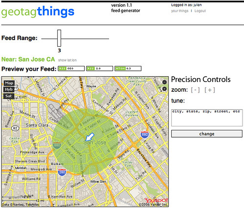
Julian Bleecker and Will Carter recently released geotagthings, a simple piece of software that allows to assign geographic meta data to arbitrary web resources.

otagthings, a new web service designed to quickly and easily assign any web resource — anything with a URL — a location in the normal, human physical world. Using Yahoo! Maps' interface and API, Geotagthings makes short work out of a previously complicated process, while providing an open feed-based mechanic for retrieving geotagged resources and displaying them in your favorite news aggregator. (description taken from their Where2.0 presentation

How it works?

Anything with a URL can be given a latitude/longitude by simply clicking a bookmarklet, picking the spot it should be assigned using a map interface, adding a little note and that's that. The URL and note get shoved into a data store where it can be accessed through an RSS feed. Anyone can get a feed for a locale simply by going to the feed generator, picking where you'd like to get a feed from, determining a range around that spot and grabbing the URL from one of the feed badges, and dropping it into your favorite news aggregator, like NetNewsWire.

Registration can be done here

Why do I blog this? because I think it's an interesting service; the why question behind that is pertinent: they ask "why" in their description and answerrfs "the network needs geographic semantics to make data resources relevant to meaningful, useful location-nased services".

Locative technologies, Where2.0

There is very soon the Where2.0 conference in San José, CA. Lots of promising stuff are going there. Judging from the description, Mike Liebhold's presentation seems to nicely wrap-up what going on so far in the field of "locative technologies/services":

Beyond a growing commercial interest in mobile GIS and location services, there's deep geek fascination with web mapping and location hacking. After several years of early experiments by a first generation of geohackers, locative media artists, and psychogeographers, a second, larger wave of hackers are demonstrating some amazing tricks with Google Maps, Flickr, and del.icio.us. Meanwhile, a growing international cadre of open source digital geographers and frontier semantic hackers have been building first-generation working versions of powerful new open source web mapping service tools. (...) Out of this teeming ecosystem we can see the beginning shapes of a true geospatial web, inhabited by spatially tagged hypermedia as well as digital map geodata. Invisible cartographic attributes and user annotations will eventually be layered on every centimeter of a place and attached to every physical thing, visible and useful, in context, on low-cost, easy-to-use mobile devices.

Lots of pertinent applications will be presented.

Also, some talks seems to discuss relevant issues that has already been brought up by some academics; such as It's Place, Not Space (by Nikolaj Nyholm, Imity, Claus Dahl, Imity):

Location is not about geography. The most important thing isn't the space you're in -- the coordinates -- but the place you're in -- the people, ideas, and interactions between them. Indeed, space is just a gateway to place: we need the coordinates to compare to other coordinates, but what we care about is proximity. The good news is that while for now the coordinate technologies like GPS are mainly available in mapping devices, there's already a great proximity technology out there, deployed in literally hundreds of millions of cell phones: Bluetooth.

And of course, some of the challenge will be described, for instance in Map Spam 2008: A Sanity Check by Michael Bauer:

The Utopian view of a world where social networking, geo-location, and mobility converge to deliver a rich, multimedia database of micro-local content is debunked. All in the spirit of fun, this presentation will apply a dose of reality to a ubiquitous mobile world. The realities of spam, tag abuse, and predictive following apps are profiled, to highlight the issues we ignore at our peril.

Why do I blog this? because my research is directed toward the understanding of such technology usage (from the socio-cognitive point of view). I think these talks efficiently describes the characteristics of the locative technology scene in 2006. What is interesting is that it addresses not only location issues but also its context: software that should support social practices (social software :( ), a real world in which things can fail and where spam exist...

There seems to be still lots of project about location-based annotations and friend-finder. I am wondering about 1) whether they are effectively used 2) how they are used 3) whether there could be innovative scenarios and usage. It seems that both are now the most commons examples, the "intelligent fridge" of the locative community.

Augmenting Guy Debord’s Derive

Talking with Adam Greenfield about his next work, I though back that I already wrote bits and pieces around the topic of how IT renew the urban experience. The report I called "Augmenting Guy Debord’s Dérive: Sustaining the Urban Change with Information Technology" (.pdf) is a bit old (2003), so the examples are a bit outdated. This is just few notes extracted from a paper I wrote with my colleague Mauro Cherubini called “To Live or To Master the city: the citizen dilemma” (Imago Urbis #2). Why do I blog this? Comments are welcome. I am not happy with the whole thing (bad english, naive ideas and almost no critical stance) but I thought that it would be good to put it online.

Spatial technology workshop at UpFing06

(sorry bad english below, I took notes in real time and recomposed them quickly) As I mentionned earlier, I had to manage a workshop about "locative media" and spatial technology today. What was interesting is that attendants had quite different ideas in mind when attending it: some were concerned by business models, other by memories in space, one or two by a curiosity towards google earth, place-based annotations, others by mobility and technology. Maybe the description on the website was a bit too narrow: since it quoted google earth, yellow arrow or flickr, different representation has been triggered in people's mind.

After introducing the whole concept and describing the fact that it is a bit messy and cover lots of practices/technologies/services/usage; there was thre presentations. The first one by Yann Le Fichant who is leading a company called voxinzebox; he explained us the different services they propose for city navigation (first on 2nd generation GSM and now on on pocketPC). He recalled us the importance of self-geolocation in that context (people declaring their own location on a cell phone to get some information about a specific place that would eventually guide them to various landmarks). He also underlined the importance of PND (personal navigation display) like TomTom or garmin that are more and more complex (improved memory, communication protocol) and could lead to new innovative tools. Yann provocatively asked why the sex industry has not yet found any big hits using location-based applications. The discussion also led Google's move in the 3D modeling by buying sketch-up (a modeling tool that would eventually allow people to model their house in 3D and put in on a google map)

Then Cyril Burger talked about his PhD research: an ethngraphy of the usage of mobile phones in the parisian subway. Cyril investigated people's behaviro and trajectory while using audio-communication and SMS. He underlined the fact that the transport facility first did not introduce any norms: so the rules that emerge were based on another norm based on how people drive. Through that code, rules of sociability emerged in terms of movements (for instance stopping in location which are not crowded so that the flow is not cut, the arrival of the metro often lead the user to stop the conversation). In terms of gesture, people stay often inanimated while texting, whereas audicommunication leads to more active/lively behavior (gestures, smiles...).

I also like his remark about the very fact that non-material places needed material places: servers need to be located somewhere. This is connected to what Jeffrey Huang talked about at LIFT06: the fact that networked technologies leads to new sort of places (and subsequently that place still matter).

Then Georges Amar (foresight manager at RATP, a subway company in france) presented the new paradigm of his company. Subway companies previously based their development on hygienist theories: efficiency was correlated with fluidity and less contact as possible (which is nicely exemplified by the non-contact RFID subway passes): the subway was disconnected with the city. Automation lead to layoff and the disappearance of controllers and even drivers, this caused the permeability of the subway (more and more insecurity, people taking it without paying): the city entered the subway. Now their model is rather about having both efficiency AND contact: let's take advantage of the presence of people, the city is in the metro and there are opportunities to have relevant services. The crowd is seen as a resource and not as a constraint. In terms of prospective services, places/stations can be transformed, new type of jobs can be created and tansporters' role change accordingly. The subway could then be seen as a PLACE to meet people, or at least to do something with others. One of the attendant mentionned the idea Starbucks had to be a place for business meetings: would the subway have certain area for business meetings? Another point is the signs that are fixed and directed to every users could be individualized for a certain category of customers (with precise interests or disabilities) or even further: the crowd's traces in space would be a material to use to create new kind of signs to foster better navigation or discovery of places or people.

After those 3 presentations, we had a discussion about different projects (current or prospective) like earthTV (seeing real-time events with google earth, this has actually been thought in the japanese subway to see where is the crowd to better avoid it), tags in google earth (very often community-based "I use linux" close to MS buidling), locator of personal objects (googling my shoes, finding my personal belongings), indoor technologies (museum), trackers (kids/prisoner tracking).

Overall, the discussion rather revolved around mobility, people and a lot about meetings, and less about technologies and usage. That's important from the rhetorical point of view: we rather dicussed the contexts and the needs (with a peculiar emphasis on the subway experience) as opposed to the technology-push projects we've seen so far: allowing PEOPLE (with a specific context: mobility, limited amount of time, limited cognitive resources because of route finding) to do something (having meetings and exchange with others, discovering information related or not to the route).

One of the conclusions here was also that innovation in spatial technologies is often due to work of peculiar companies such as RATP (subway companies), JCDecaux (urban ads) which are ubiquitous and bound to specific mobile needs. Soome researchers from a french phone operator acknowledged the fact that innovation is very tough for them because everything is either locked or behind walled gardens when it comes to phone (SIM cards, low interoperability, different standards, hard to use voice / location based application, different kind of phones/handhelds...). This resonates with discussions we had at the lab (see here or there).

Technorati Tags: ,

Workshop about spatial technologies at UpFing06

Currently a Université de Printemps de la FING 06, which is a big gig organized by la FING, a french think tank working on innovation and IT. The venue is quite nice, an old catholic mansion:

upfing (1) upfing (2)

The reason why I am here is because I have to take care of a workshop here about spatial technologies, in the broad sense (locative media, location-based services, place-based annotations platforms...). The event is in french.

Here are the slides of my presentation (in french, pdf, 3.8Mb). I actually described the following issues: - when we look at the terms we use when we talk about spatial tech, it's very diverse (ranging from geowanking to locative media, geotagging or buddy-finder). Sometimes, it's about practices, sometimes about technologies, sometimes services... - we will focus on a specific subpractice: place annotation - what is interesting is that the usages regarding that practice seem to be diverse but this is does not take a diachronic perspective (the fact that people annotated space a LONG time ago), nor the size of the target group of user (% of tech-savvy persons? % of total population). - some of the most interesting examples will be presented (yellow arrow, flickr notes, stamps...) - and I will describe why this is important in terms of socio-cognitive processes: the fact that space affords specific interaction, shape people's behavior and agency. People leave traces in space and then decode them as cues for acting.

I will put some more notes later about people's intervention, the subgroup activity and the conclusion.

Technorati Tags: , ,

Students and location-based services in context

Barkhuus, Louise and Paul Dourish, "Everyday Encounters with Context-Aware Computing in a Campus Environment". In Proceedings of UbiComp 2004, Nottingham, UK, 2004. The paper is an empirical investigation of the use of a ubiquitous computing system blending mobile and location-based technologies to create augmented experiences for university students (i.e. the Active Campus system, developed and deployed at UC San Diego). The focus is on how the technology fits into broader social contexts of student life and the classroom experience. This is not an evaluation of specific technologies, they rather deploy a technological setting to reflect upon some broader patterns of technology use (that would eventually lead to implications for designs), taking an institutional approach (influences of adoption and analyze the emergent practices from an institutional view point). This point is important since it allows to have a broader discussion of the technological impacts.

The conclusion is quite interesting:

Where students, on the surface, seem like the perfect probes for new technology, their inherent social structures and high level of nomadicity creates a tension between their desired use and actual possibility for use. From the perspective of research, many settled practices and infrastructures within the campus environment are inhibiting not only the adoption of new technology but also the foundation for testing new technologies. Only by looking beyond the technologies themselves, towards the broader institutional arrangements within which they are embedded, can we begin to understand the premises for deployment of ubiquitous technology.

And of course, there are some important elements that are connected to my research about the usage of location-awareness of others in collaborative settings.

Separately from the problems of mobility, we can also ask, how and when does location manifest itself as a practical problem for students? Location-based services developed in other settings point to a range of ways in which ubiquitous computing technologies can help people resolve location-based problems - the most common being finding resources, navigating in unfamiliar environments, and locating people.

As we have noted, students’ experience is primarily nomadic, and since their activities and concerns are driven as much by the demands of social interaction as by their studies, we had anticipated that services such as the people finder would be of value, helping them to locate each other as they moved around a campus environment. However, further examination showed that, in fact, location rarely manifests itself for them, practically.

This is also something we discussed here at the lab, and eventually lead to some tough issues regarding a location-based annotation project we had. There was not really a need to design those virtual post-its in the context of the school.

I also find this relevant to my work:

Because of the regularity of their schedules, the students, then, tend to find themselves in the same part of the campus at specific times in the week. Similarly, their friends live equally ordered lives, with locations determined by class schedules, and our respondents seemed as familiar with aspects of their friend’s schedules as with their own. Mutually-understood schedules, then, provide them with the basis for coordination.

A result like this is connected to the framework of coordination I used (Clark's theory of coordination). Among all the coordination "devices" people rely on, conventions or mutually acknowledged agreement like common schedule are a common way to infer other's activity (and hence whereabouts).

Finally, the last part is about the fact that "There being no home base, students have no expectation of being able to find each other in fixed places; instead, class schedules become a primary orienting mechanism around which location is determined and coordination is achieved". It reminds me a paper I saw a month ago at COOP2006 called "On a Mission Without a Home Base: Conceptualizing Nomadicity in Student Group. Work" by C. Bogdan, C. Rossitto, M. Normark, P. Jorge (Adler) and K. Severinson. The paper also addresses that issue.

A space-labeling technology

A curious project presented at SIGGRAPH: it's called Instant replay and it's done by folks from Mitsubishi Electric Research Laboratories (MERL).

Real-world, slow-motion instant replay for air hockey. This new space-labeling technology tracks the pucks with a high degree of accuracy and speed (1cm/500Hz) in natural illumination without visible tags.

This system uses infrared optical data projection and hardware tags to provide tracking data for many objects that are moving and rotating very quickly. Because the tags are very inexpensive, many of them can be deployed in harsh conditions.

The core technical innovation of this work is the system's space-labeling technology. The projectors are inexpensive, solid-state, high-speed devices that project invisible (infrared) patterns 10,000 times a second. By sensing 20 patterns (1/500th of a second), passive tags are able to decode their own location. Because the entire space is labeled, the speed of the system remains constant no matter how many tags are tracked. The tags use very inexpensive, off-the-shelf IR-decoding modules and microcontrollers. The projectors are also very inexpensive. In addition to decoding their location, the tags have the ability to detect their orientation and record incident illumination.

Why do I blog this? yet another location detection technology (just keeping track of stuff).

Galileo, assisted GPS and potential users

IHT describes the few points about Galileo, its 5 levels of services of Galileo (the European quasi-GPS) and other interesting things with regards to locative technologies:

Galileo would have five levels of service, the most basic of which would be free, like GPS. The others would be commercial and offer higher levels of accuracy, security, strength or a combination of those qualities. The second tier of service would be designed for basic commercial applications like truck-fleet management, while the third would be accurate enough for more sophisticated services like assisting aircraft to land or guiding ships loaded with dangerous materials through coastal waters, he said. The fourth level would offer higher security in the form of encryption and anti-jamming measures and would be used by government authorities like the police, ambulance drivers, fire brigades and the armed forces, de- Ledinghen said. The final tier would be used for search and rescue and would offer a unique two-way service, providing the sender of a distress signal an acknowledgment of its receipt.

The article also mentions the current assisted GPS:

Several services around the world offer enhanced, or assisted, navigation services based on the open GPS service. Such services enhance GPS with additional geostationary satellites and ground stations that monitor the GPS signals and correct them. (...) while normal GPS is hindered by buildings, trees or anything else that blocks out the sky, "assisted" GPS works much better in urban canyons and can even operate indoors. (...) Alcatel and Orange, the mobile operator owned by France Télécom, conducted a trial from October to February in which 200 users were given Hewlett-Packard devices that combined the functions of an advanced mobile phone and an assisted-GPS receiver. The gadgets allowed users to roam around towns on foot, with accurate maps beamed to them via the mobile network. Alice Holzman, marketing director at Orange France, said the customers were impressed with the speed and accuracy of the devices. She said the increased accuracy of assisted GPS made it feasible for mobile phone operators to offer services to track valuables or for applications like emergency services and medical assistance. More "fun" services like friend finding and mobile gaming will use the technology when costs come down, she added.

Why do I blog this? since I am interested by the user experience of location-based applications, I'd like to know more than " customers were impressed with the speed and accuracy of the devices", what does that mean in terms of people's behavior: is it " Phew wow my assisted GPS is so accurate!" or a "ok I have to make a right and a left to finally find my car"? That's really an important topic, when it comes to how people feel technologies' discrepancies, accuracy (or non accuracy) and responsiveness.

GeoRSS aggregator

Brainoff has posted this mapufacture, a geoRSS aggregator:

mapufacture is a GeoRSS aggregator. here you can layer multiple GeoRSS feeds from different sources into a single map, and search the database of GeoRSS feeds by keyword and location. search results are themselves available as GeoRSS feeds. if you do want to create a map, we ask that you go through a simple registration process.

Why do I blog this? this is the new trend, aggregating different flows of information on top of a spatial representation using the simple RSS adaptations. I like the idea of having search results as geoRSS feeds.

What I also find interesting is the fact that those RSS derived standards are more and more available and this should eventually lead to more interesting aggregating interfaces, what are the progress in this area so far? Lots of components could be helpful (spatial, social, datamining features...).